
Climate Shift Index Alerts
Using our Climate Shift Index (CSI) system (including Ocean CSI and Tropical Cyclone CSI), we issue alerts when select extreme weather events — such as heat waves, hurricanes, or wildfires — are made more likely by human-caused climate change.
Explore the log below to see a sampling of recent events linked to climate change, and use the CSI and Ocean CSI map tools to investigate daily conditions in your area.
Want to receive these alerts? Join our email list.
Climate change boosts unusual October heat across the U.S.
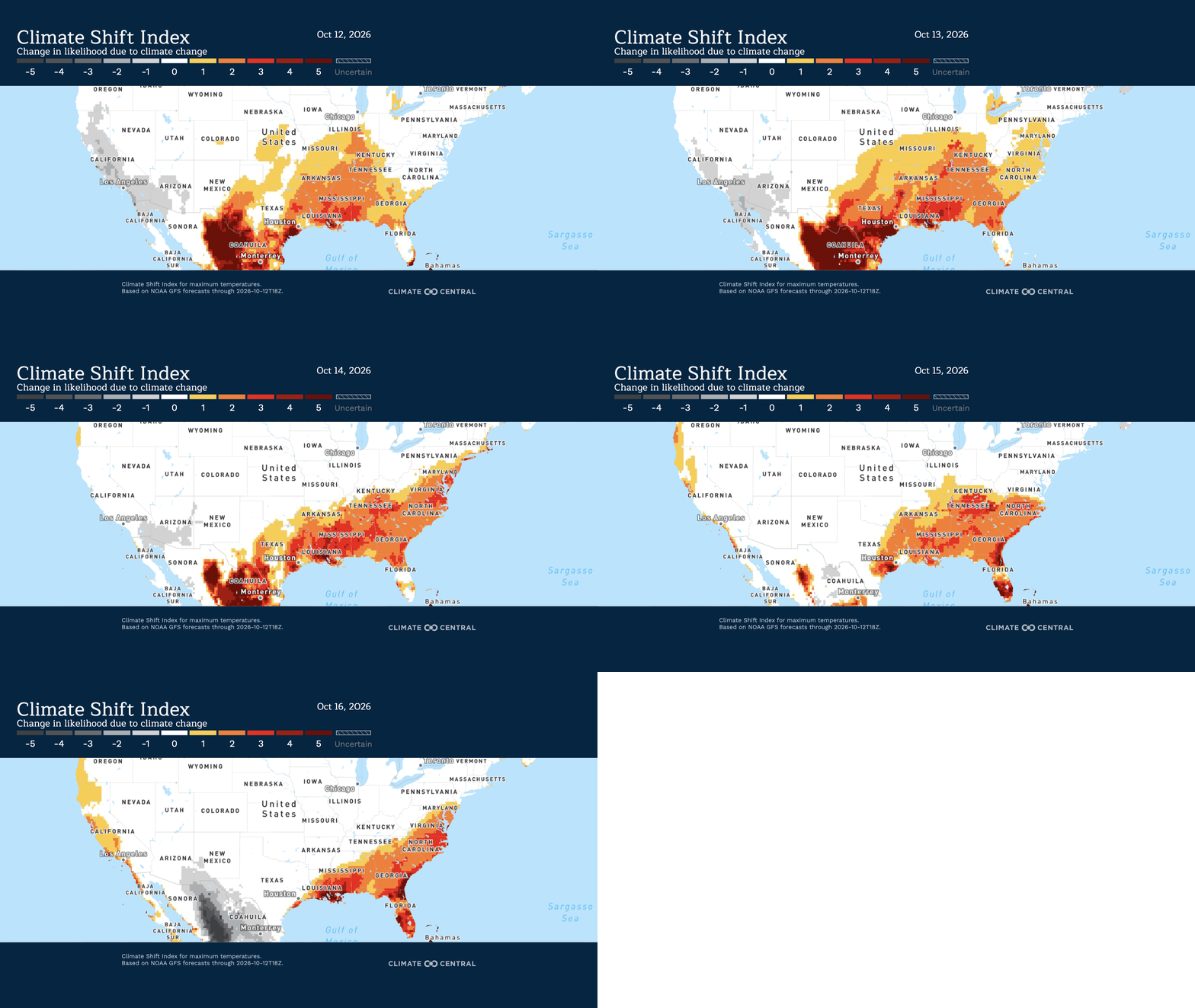
Unusually high October temperatures are forecast across a broad swath of the U.S. this week, bringing hot and humid conditions to parts of the Texas Gulf Coast and near-record warmth farther east.
The heat will affect communities recovering from Hurricane Isaias in the Florida Panhandle and southern Alabama, where widespread power outages have disrupted access to air conditioning and storm cleanup efforts are ongoing. These conditions could increase the potential for heat-related illness, particularly among those without power and people working outdoors to clear debris and repair storm damage.
How unusual is the forecasted heat?
Unusually warm October temperatures are forecast across the U.S. from October 12-16, as a strong ridge of high pressure extends from the Gulf Coast northward through the Mississippi Valley and into the Midwest. Daily high temperature records could be tied or broken across portions of the Lower Mississippi River Valley, Mid-South, and Southeast through Thursday, with record highs in parts of Illinois early in the week.
Southern Texas and the Lower Mississippi Valley: Highs of 90-97°F (32–36°C) are forecast across eastern and southern Texas, Louisiana, Mississippi, eastern Arkansas, and western Alabama. These temperatures will run 7-22°F (4-12°C) above normal across Texas, Louisiana, and western Mississippi, with the largest departures from normal across Arkansas and northern Mississippi. Along the Texas Gulf Coast, wet-bulb temperatures will reach 77-79°F (25-26°C), levels considered dangerous because of the risk of heat-related illness.
Midwest and Ohio Valley: Highs of 91-97°F (33–36°C) are forecast across Missouri, Illinois, western Tennessee, and Indiana, and parts of Kentucky later this week. Temperatures will generally be 14-22°F (8-12°C) above normal, with some areas of eastern Missouri and central Illinois forecast to reach 27-29°F (15-16°C) above normal
Southeast: Highs of 85-90°F (29-32°C) are forecast across the Florida Panhandle, southern and eastern Alabama, Georgia, the Carolinas, and some portions of Virginia. Temperatures will be 6-20°F (3-11°C) above normal, with the largest departures across northern portions of the region later this week.
How has climate change influenced this heat?
Climate Shift Index (CSI) levels of 5 — the highest possible — are forecast in San Antonio, Houston, and Miami, meaning human-caused climate change made this extreme heat at least five times more likely. This signals an exceptional climate-influenced event.
From October 12-16, more than 85 million people from the Gulf Coast northward through the Mississippi Valley and into parts of the Midwest will experience at least one day with average temperatures reaching a CSI 3 or higher, indicating an exceptional influence from climate change.
Climate change contributed to severe coastal flooding in Southern California
From October 9 to 12, large waves and unusually high tides caused coastal flooding and erosion across Southern California, damaging homes, flooding roads, and disrupting access to beaches.
Seawater inundated low-lying coastal neighborhoods, particularly around Newport Beach, where officials declared a local emergency. Farther inland, the remnants of Tropical Storm Rachel brought heavy rainfall and strong wind gusts to the Coachella Valley, causing flash flooding.
The coastal flooding resulted from a combination of factors, including:
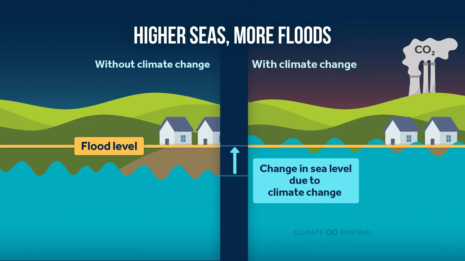
Human-caused sea level rise associated with climate change, which has raised sea levels along the Southern California coast by about 6.5 inches since 1900.
Elevated sea levels caused by an El Niño-associated Kelvin wave. Kelvin waves are underwater waves that often travel eastward across the tropical Pacific before continuing along the coasts of the Americas, where they can temporarily raise coastal sea levels;
Naturally occurring high tides.
Large waves associated with Tropical Storm Rachel.
This Kelvin wave contributed to sea levels already elevated due to climate change. High tides raised water levels further, while large waves from the remnants of Tropical Storm Rachel pushed water onshore, creating conditions for severe and damaging flooding and erosion.
Climate influence:
Over the three days from October 9-11, Southern California communities experienced coastal flooding that was either not possible without climate change or was worsened by climate change.
The San Diego tide gauge station registered minor flood conditions each day during this period, and each day, those conditions would not have been possible without the roughly 6.5 inches of sea level rise that have occurred in the region due to human-caused climate change.
Sea level rise attributable to climate change also worsened flood conditions in communities around the Los Angeles and Santa Monica tide gauge stations, though both would have experienced minor coastal flooding even in the absence of climate change.
The tide gauges at San Diego, Los Angeles, and Santa Monica have each logged more than 25 days with coastal flood conditions so far in 2026. At each location, the majority of those coastal flooding events would not have occurred without human-caused climate change.
Climate change supercharged the warm Gulf waters fueling Hurricane Isaias
Isaias underwent rapid intensification in the western Gulf of Mexico between October 7 and 8, strengthening from a tropical storm to a hurricane. By Friday, October 9, the storm rapidly intensified again, strengthening to a Category 3 hurricane. Isaias is moving over exceptionally warm Gulf of Mexico waters and is forecast to make landfall on the Gulf Coast between Alabama and Florida late Friday, October 9.
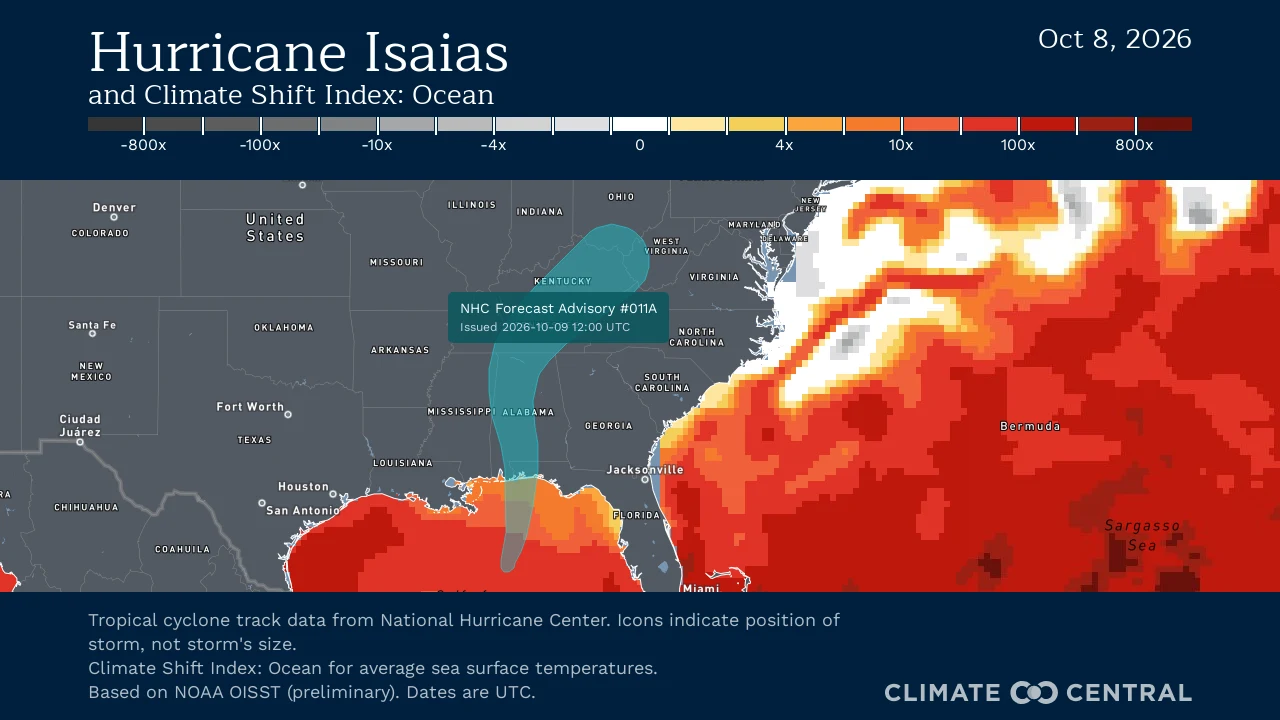
The exceptionally warm, record sea surface temperatures fueling this storm across the western and central Gulf of Mexico are up to 600 times more likely due to human-caused climate change. The waters over which Isaias formed before becoming a named storm were up to 800 times more likely. These warm waters significantly enhance the storm’s potential strength.
According to the National Hurricane Center, life-threatening storm surge is expected along portions of the Gulf Coast, from the mouth of the Mississippi River to Suwannee, Florida. Damaging hurricane-force winds are expected across parts of the Florida Panhandle, southern Alabama, and southern Mississippi, with gusts possibly extending farther inland. Heavy rainfall is expected across the central Gulf Coast and much of the Southeast through the weekend.
Find frequently updated information about how climate change may impact this storm at Isaias and climate change.
How is climate change influencing this storm?
Isaias underwent rapid intensification over waters that were 1.4°C (2.4°F) warmer on average than they would have been in a world without climate change. These unusually warm Gulf waters, exceeding 31°C (88°F), were made 4 to 600 times more likely due to human-caused climate change.
The Gulf’s warmer oceans supercharge tropical systems’ ability to carry moisture, adding to the ongoing flood concerns, especially across southern Alabama, the Florida Panhandle and Big Bend, and southwest Georgia through the weekend.
Isaias could bring a substantial storm surge to the Gulf Coast. Human-caused climate change has raised sea levels in this region by about 6.5 inches since 1900, allowing storm surges to reach higher levels and increase their potential for destruction.
Climate change is forecast to add 7 mph to Isaias's maximum sustained wind speeds.
California heat wave, intensified by climate change, continues into October
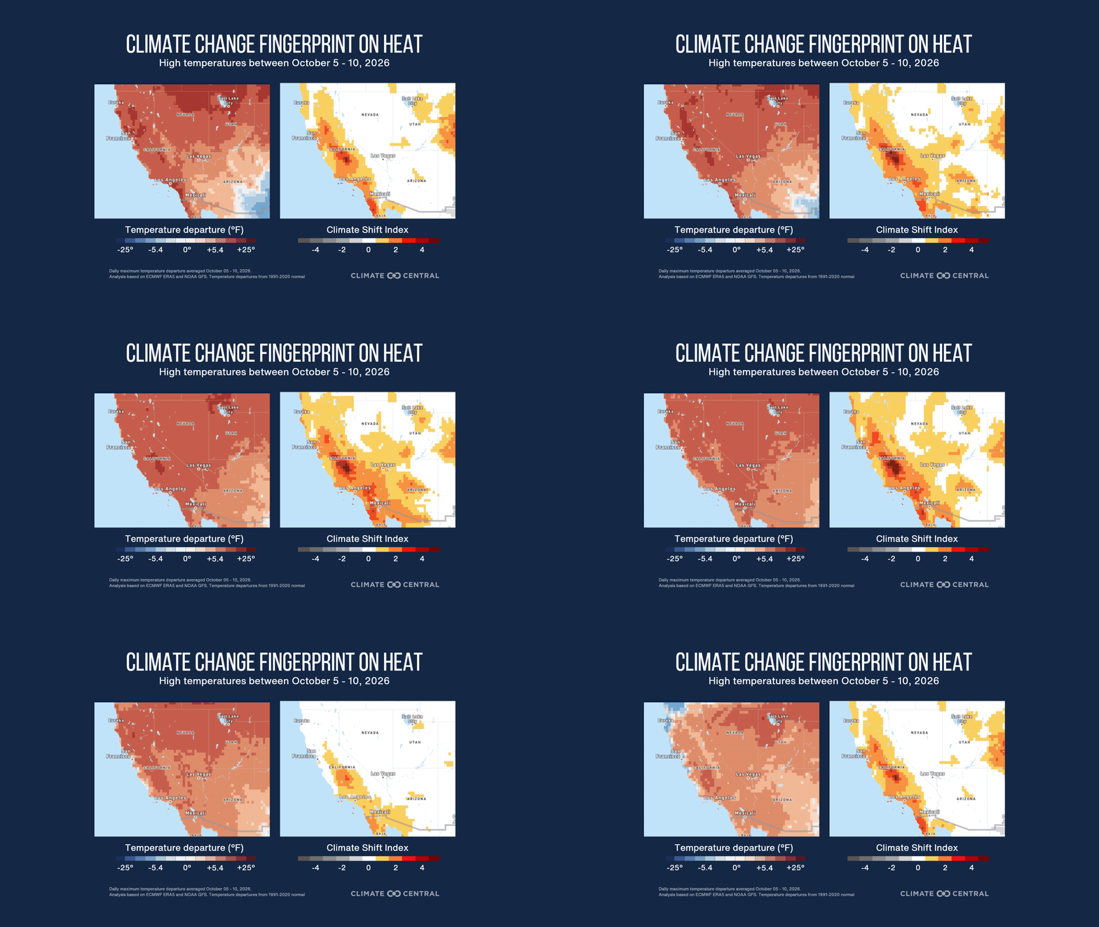
Extreme heat is persisting across California, with temperatures reaching above 100°F in parts of the state through October 7. These temperatures are up to 20°F above average for this time of year. Human-caused climate change made this unusual heat at least two times more likely. More than 37 million Californians are expected to experience temperatures at least three times more likely due to climate change.
Unusual temperatures:
Heat alerts remain in effect for a large portion of California. Extreme Heat Warnings continue in Los Angeles and San Diego, while Heat Advisories are in place in Chico, Fresno, Redding, Sacramento, San Francisco, and San Jose.
Daytime high temperatures over the first weekend of October reached the mid-to-upper 90s and triple digits. This unusual heat is forecast to continue through Wednesday, October 7, with cities like Bakersfield, Fresno, Sacramento, and Stockton reaching 100°F to 102°F.
Late in the week, highs will fall into the mid-to-upper 90s in these areas, with highs of 90°F to 95°F between Los Angeles and San Diego.
For early October, this excessive heat is as much as 15°F to 20°F above average.
According to the National Weather Service, “the expected temperatures will result in Major to Extreme HeatRisk along with numerous daily high temperature records. Heat of this intensity and duration can endanger anyone without adequate cooling or hydration.”
Climate influence:
From October 5 through October 10, more than 37 million people across California will experience at least one day with maximum temperatures reaching a CSI 2 or higher (94% of the state population), indicating an exceptional influence from climate change.
Maximum temperatures made at least two times more likely by human-caused climate change are projected to affect over half of the land area, or 92,000 square miles (239,000 square kilometers) of California.
Unusually warm Gulf of Mexico waters boosted by climate change raise odds of tropical development, heavy rain
The National Hurricane Center is monitoring an area of potential tropical development in the Gulf of Mexico. As of Tuesday, October 6, this area of low pressure, known as Invest 92L, was given a 90% chance of forming into a tropical system by mid-week. Regardless of development, heavy rainfall is forecast for portions of the Gulf Coast, with 4 to 6 inches of rain possible, and localized higher totals in coastal Alabama, Louisiana, Mississippi, and northern Florida.
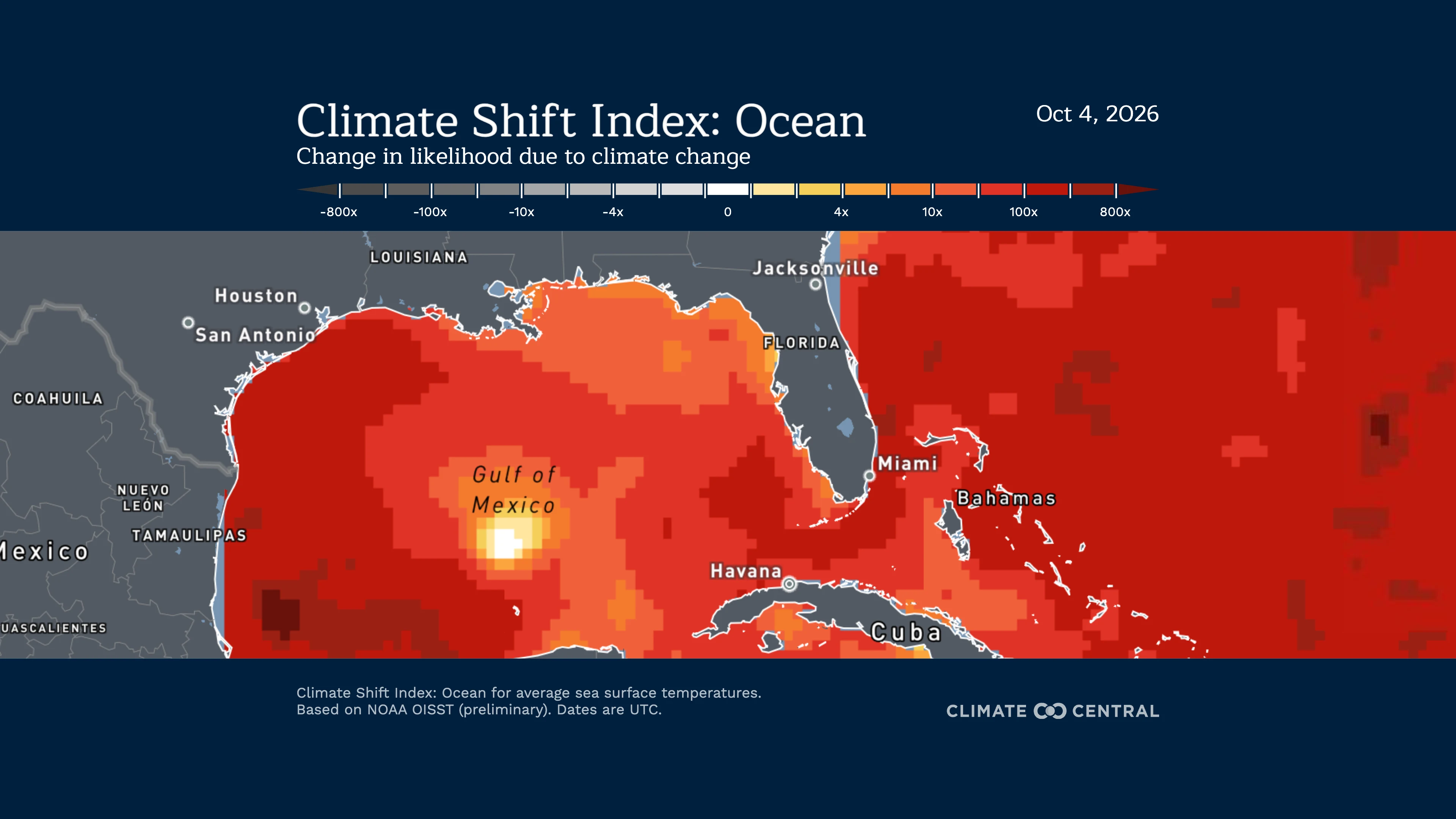
Note: This is NOT a storm forecast. Visit the National Hurricane Center for the latest updates and information on how the storm is evolving.
How is climate change influencing this storm?
This area of low pressure is currently over waters in the southwestern Gulf where sea surface temperatures are being made 300 to 800 times more likely by human-caused climate change.
Warmer air can hold more moisture, and warmer ocean waters increase evaporation, adding more water vapor to the atmosphere that can contribute to rainfall as the system develops.
How do we know climate change is influencing this storm?
The Climate Shift Index: Ocean is grounded in peer-reviewed methodology and high-quality data. It quantifies the influence of climate change on sea surface temperatures.
The Ocean CSI indicates how human-caused climate change has influenced the likelihood of daily sea surface temperatures occurring at nearly any location around the world’s oceans.
Climate change worsened coastal flooding during East Coast nor’easter
Last weekend’s nor’easter brought damaging coastal flooding to the East Coast — higher seas driven by climate change made the impacts worse.
How did climate change influence this storm?
As sea levels rise due to climate change, high-tide flooding is becoming more common along U.S. coasts. In many cities affected by last weekend’s nor’easter, most coastal flood days would not have occurred without human-caused climate change.
During storms like this one, higher sea levels mean that storm-induced increases in water levels are more likely to cause flooding on land, and the flooding that occurs is likely to be deeper and more extensive than it would have been without climate change.
Based on peer-reviewed science, Climate Central calculated the effect of sea level rise due to human-caused climate change on the flooding conditions recorded at tide stations up and down the East Coast during the nor’easter. We found that climate change significantly worsened flood conditions from South Carolina to Massachusetts.
Climate change is adding fuel to this weekend’s Nor’easter
A developing nor’easter is expected to strengthen along the U.S. East Coast through the weekend, bringing heavy rainfall, strong winds, dangerous surf, and coastal flooding from the Mid-Atlantic into New England. As of September 24, coastal flooding has already affected portions of Virginia and North Carolina, with ocean overwash closing a miles-long stretch of road on the Outer Banks and breaking waves of 12-17 feet forecast along Hatteras Island, North Carolina.
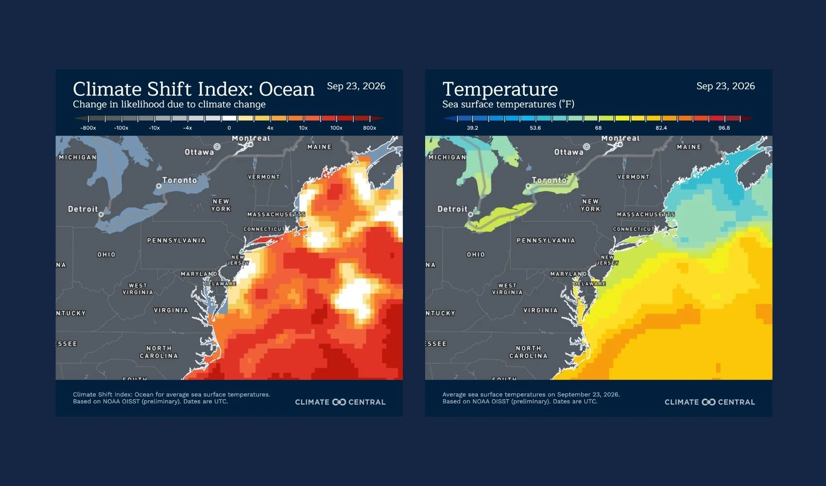
The storm is expected to bring its most significant impacts to the Northeast beginning Friday, with coastal wind gusts of 40-60 mph and widespread rainfall totals of 2-4 inches, with isolated amounts reaching 5 inches on Cape Cod.
Dangerous surf is expected, with coastal flooding possible along much of the Northeast coast Friday through Sunday, including the Jersey Shore, Long Island, Rhode Island, Martha's Vineyard, Nantucket, and portions of coastal New Hampshire and Maine. Breaking waves of 6-17 feet are possible along the Massachusetts coast, while offshore seas near Jeffreys Ledge in the Gulf of Maine could reach 15 feet. Prolonged onshore winds and repeated high tides, amplified by Saturday’s full moon, will increase the risk of coastal flooding, beach erosion, and damage to coastal infrastructure
How is climate change influencing this storm?
The developing nor’easter is forming over exceptionally warm Atlantic waters off the Mid-Atlantic coast, where sea surface temperatures of 81-83°F are 2-4.5°F above normal.
According to Climate Central’s Climate Shift Index: Ocean, these unusually warm waters have been made 10 to 50 times more likely by human-caused climate change.
As the storm moves northward, it is expected to travel over unusually warm waters of 75-80°F, approximately 2-4°F warmer than normal.
Ocean CSI along its forecast path indicates that these ocean temperatures are 10 to 50 times more likely, and up to 70 times more likely in some areas, due to climate change.
Warmer waters can increase evaporation and supply additional moisture to the atmosphere, potentially enhancing rainfall as the nor’easter moves along the East Coast.
Human-caused climate change is also contributing to rising sea levels and exacerbating flooding outlooks along the East Coast. Tide forecasts for Lewes, Delaware, for example, indicate that the region could experience moderate coastal flooding in the coming days, but would experience only minor flooding without the influence of human-caused sea level rise. Similarly, New York City is expected to experience minor coastal flooding, but without the influence of human-caused climate change, sea levels would not reach flood levels at all.
Climate change amplifies extreme heat across much of South America
Extreme heat is forecast across large portions of South America this week, with temperatures reaching up to 47°C (117°F) in some areas. Climate change made the exceptional heat at least five times more likely across millions of square kilometers, affecting more than half the continent’s population.
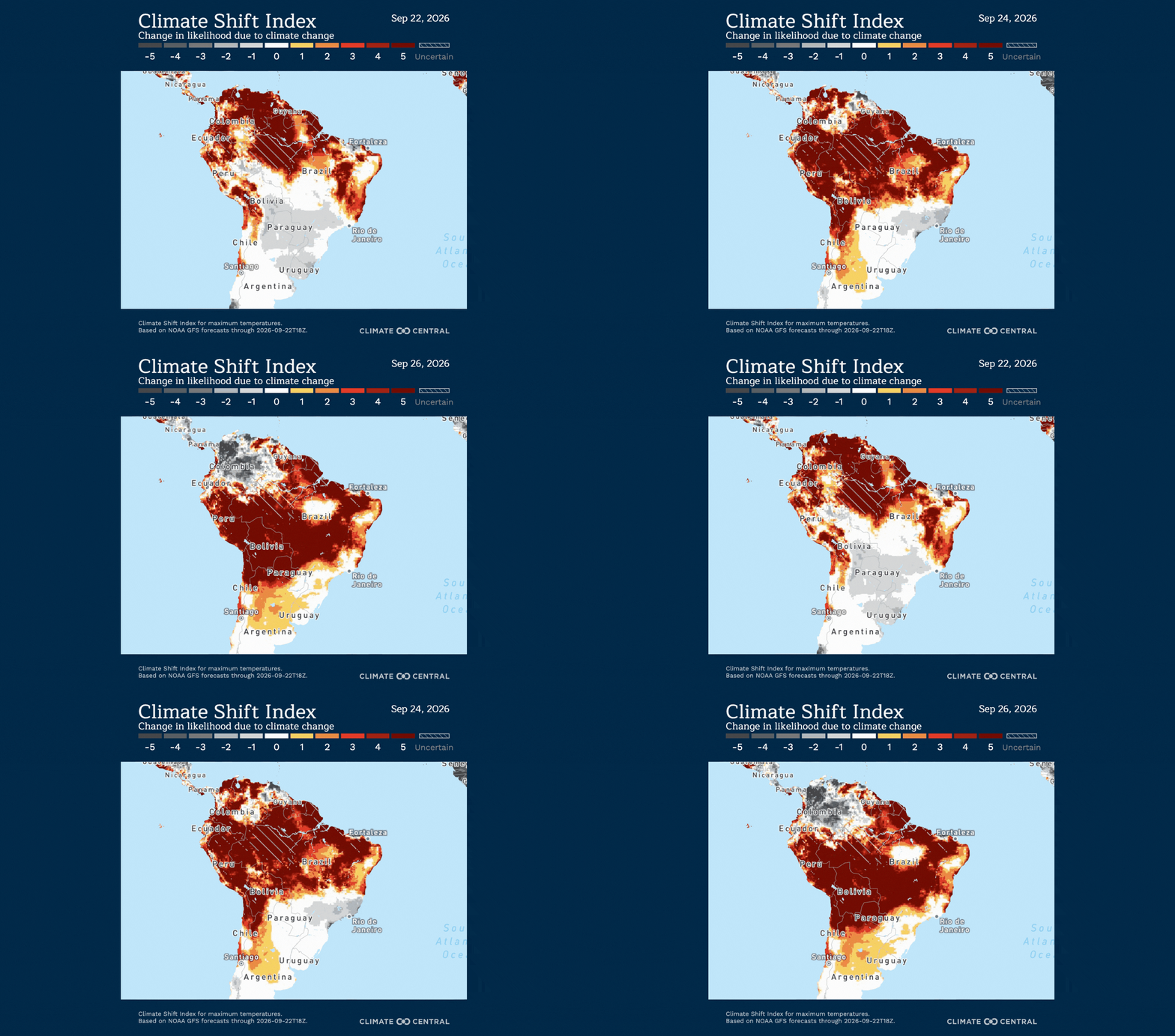
Unusual temperatures:
Persistent warmth is affecting large portions of the northern and tropical regions of South America this week.
From September 22-26:
Northern and central Brazil, Colombia, Venezuela, and French Guiana: Temperatures of 33-39°C (91-102°F), which are 2-7°C (4-13°F) above normal for this time of year.
Peru: Temperatures of 34-39°C (93-102°F) in northern and eastern portions of the country, with temperatures up to 41°C (106°F) possible in the southeast later this week. These temperatures are 3-10°C (5-18°F) above normal for this time of year.
From September 24-26:
Northern Argentina, western and northwestern Paraguay, and Bolivia: Temperatures up to 41-47°C (106-117°F), which are up to 9-15°C (16-27°F) above normal for this time of year.
The current warmth is consistent with the International Center for Research on the El Niño Phenomenon’s (CIIFEN) regional outlook, which forecasts above-normal temperatures across much of South America for September-November as El Niño strengthens.
El Niño is a naturally occurring climate pattern, but it is unfolding against a warmer background due to human-caused climate change, which can amplify heat during El Niño-influenced periods
Climate influence:
Climate Shift Index (CSI) levels of 5 — the highest possible — are forecast across much of South America, with the highest concentrations in Brazil, Venezuela, and Peru from September 22-26, meaning human-caused climate change made this extreme heat at least five times more likely. This signals an exceptional climate-influenced event.
From September 22-26, more than 251 million people, or over half of the population, across South America are forecast to experience at least one day with average temperatures reaching a CSI 5 or higher, indicating an exceptional influence from climate change.
Temperatures made at least five times more likely by human-caused climate change are projected to affect approximately 12.8 million square kilometers (4.9 million square miles) — an area more than 3 times larger than India.